History of Lake Bonneville
Ancient Lake Bonneville was located in north-central Utah and was fed by the Bear River, until 14,500 years ago, during the Pleistocene Epoch. Lake Bonneville was the largest stage of the ancient lake that is now the Great Salt Lake. After the Lake Bonneville Flood, the lake fell to the Provo shoreline level.
Lake Bonneville Close Up:
The history of Lake Bonneville is also the history of the Great Salt Lake. The modern lake is a small residual of Bonneville, a pleistocene lake that at its peak covered 52,000 sq km (32,000 sq mi) in what is now northwestern Utah and Southern Idaho. Several distinct stages have been identified at which lake levels remained constant for periods of one thousand years or more; these are called Stansbury, Bonneville, Provo, and Gilbert. The highest stage, Bonneville, was cut short by a massive flooding event about 14,500 years ago through the Red Rock pass area near Zenda, Idaho.This event released about five thousand cubic kilometers of water - the second largest flood in the geologic history of the world.
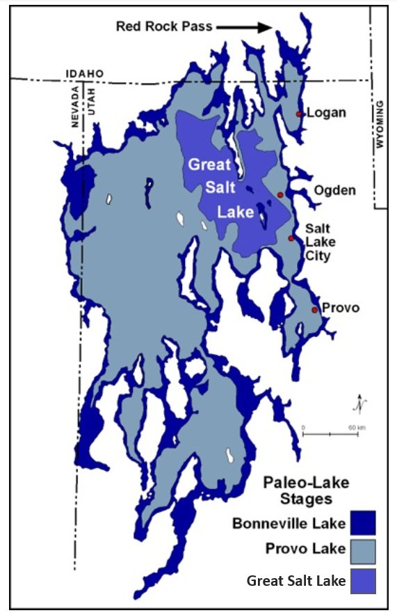
Fig1
Map of the Great Salt Lake, Lake Provo and
Lake Bonneville
The map shows all of the lake stages from the past 23,000 years. The levels, from lightest to darkest, are Bonneville, Provo, Stansbury, Gilbert, and the contemporary Great Salt Lake. The chart below shows the changes in lake levels over time.